OFFICIAL
DESCRIPTION CHANGE
OFFICE:
Transportation Data
ENTERED
BY: Stefani Wonders
ENTERED
DATE: 09-18-2006
DISCUSSION/BACKGROUND:
Due to a review
of our Primary System records, the primary route description for Interstate 29
in Woodbury County was revised.
PROPOSAL/ACTION
RECOMMENDATION:
New
Description - Interstate 29 and its extensions in Woodbury County
described as follows:
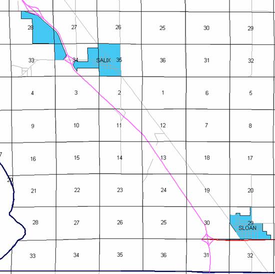
Beginning on
the Woodbury‑Monona County line at a point near the S ¼ Corner Section 31‑T86N‑R46W,
Woodbury County (N ¼ Corner Section 6‑T85N‑R46W, Monona County);
thence northerly and northwesterly through Sections 31, 30 and l9‑T86N‑R46W,
Sections 24, 13, 12, 11, 2 and 3‑T86N‑R47W, and Sections 34, 27,
28, 21, 20, 17, 8, 7 and 6‑T87N‑R47W to a point 240 feet west of
the N ¼ Corner Section 6‑T87N‑R47W; thence northwesterly and
northerly through Section 31‑T88N‑R47W to the south corporation line
of Sergeant Bluff connecting with an unnamed street (approximately 1183 feet
east and 329 feet south of the NW Corner of said Section 31).
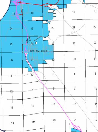
Sergeant
Bluff:
Beginning
on the south corporation line connecting with an unnamed street; thence northeasterly
through Sections 31 and 30‑T88N‑R47W to the north corporation line
(approximately 2641 feet north and 1356 feet east of the SW Corner of said
Section 30).
Beginning again on the north corporation line of Sergeant Bluff
connecting with an unnamed street; thence northeasterly through Section 30‑T88N‑R47W
to the south corporation line of Sioux
City connecting with an unnamed street (approximately 2716
feet north and 1370 feet east of the SW Corner of said Section 30).
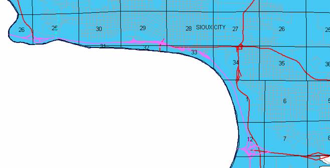
Sioux City:
Beginning on
an unnamed street at the south corporation line; thence northerly, northwesterly,
and northerly on said unnamed street through Sections 30 and 19-T88N-R47W and
Sections 24, 13, 12, and 1-T88N-R48W to a point approximately 850 feet west of
the S ¼ Corner Section 34‑T89N‑R47W; thence curving in a
northwesterly direction on unnamed street through Sections 34, 33 and 28‑T89N‑R47W;
thence continuing westerly through Sections 29 and 30‑T89N‑R47W and
Section 25‑T89N‑R48W to a point approximately 1526 feet south of
the Center Section 25‑T89N‑R48W; thence westerly on an unnamed
street to a point approximately 1671 feet south of the W ¼ Corner Section 25‑T89N‑R48W;
thence in a westerly and northwesterly direction through Section 26‑T89N‑R48W
to the west corporation line of Sioux City at a point on the Big Sioux River
Bridge (Iowa‑South Dakota State Boundary).
OFFICIAL
DESCRIPTION CHANGE
COUNTY:
Woodbury
ROUTE:
Interstate 29
STAFF
ACTION NUMBER: S-87-1498
APPROVAL
DATE: 5-13-87
New
Description ‑ Interstate 29 and its extensions in Woodbury County
described as follows:
Beginning on
the Woodbury‑Monona County line at a point 187 feet east of the S ¼
Corner Section 31‑T86N‑R46W, Woodbury County (N ¼ Corner Section 6‑T85N‑R46W,
Monona County); then north and northwest through Section 31‑T86N‑R46W
to a point 68 feet west of the N ¼ Corner said Section 31; then continuing in a
northwesterly direction through Sections 30 and l9‑T86N‑R46W to a
point 1,361 feet north of the SW Corner Section 19‑T86N‑R46W; then
continuing in a northwesterly direction through Sections 24, 13, 12, 11, 2 and
3‑T86N‑R47W to a point 384 feet east of the N ¼ Corner said Section
3; then continuing in a northwesterly direction through Section 34‑T87N‑R47W
to a point approximately 851 feet west of the center of Section 34‑T87N‑R47W;
then continuing in a northwesterly direction through Sections 34, 27, 28, 21,
20, 17, 8, 7 and 6‑T87N‑R47W to a point 240 feet west of the N ¼
Corner Section 6‑T87N‑R47W; then northwest and north through
Section 31‑T88N‑R47W to the south corporation line of Sergeant
Bluff connecting with an unnamed street.
Sergeant
Bluff:
Beginning on
the south corporation line connecting with an unnamed street; then north
through Sections 31 and 30‑T88N‑R47W to the north corporation line
(south corporation line of Sioux City),
connecting with an unnamed street.
Sioux City:
Beginning on
the south corporation line (north corporation line of Sergeant Bluff); then
north to the north corporation line, connecting with an unnamed street.
Beginning
again on the north corporation line of Sioux City,
connecting with an unnamed street; then north through Section 30‑T88N‑R47W
to the south corporation line of Sioux
City, connecting with an unnamed street.
Sioux City:
Beginning on
the south corporation line connecting with an unnamed street; then in a
northerly and northwesterly direction through Section 19‑T88N‑R47W
and Sections 24, 13, 12 and 1‑T88N‑R48W to a point approximately
850 feet west of the S ¼ Corner Section 34‑T89N‑R47W; then curving
in a northwesterly direction on unnamed street through Sections 34, 33 and 28‑T89N‑R47W;
then continuing westerly through Sections 29 and 30‑T89N‑R47W and
Section 25‑T89N‑R48W to a point approximately ¼ mile south and ¾
mile east of the center of Section 25‑T89N‑R48W; then westerly on
an unnamed street to a point approximately ¼ mile south of the W ¼ Corner
Section 25‑T89N‑R48W; then in a westerly and northwesterly
direction on unnamed street through Section 26‑T89N‑R48W to the
west corporation line of Sioux City at a point on the Big Sioux River Bridge
(Iowa‑South Dakota State Boundary).
OFFICIAL
DESCRIPTION CHANGE
COUNTY:
Woodbury
ROUTE:
Interstate 29
APPROVAL
DATE: Revised 5-13-87
Locate
Interstate 29 and its extensions in Woodbury
County as follows:
Beginning on
the Woodbury‑Monona county line at a point 187 feet east of the S ¼
Corner Section 31‑T86N‑R46W, Woodbury County (N ¼ Corner Section 6‑T85N‑R46W,
Monona County); thence northerly and northwesterly through Section 31‑T86N‑R46W
to a point 68 feet west of the N ¼ Corner said Section 31; thence continuing,
in a northwesterly direction through Sections 30 and 19‑T86N‑R46W
to a point 1361 feet north of the SW Corner Section 19‑T86N‑R46W;
thence continuing in a northwesterly direction through Sections 24, 13, 12, 11,
2, and 3‑T86N-R47W to a point 384 feet east of the N ¼ Corner said
Section 3; thence continuing in a northwesterly direction through Section 34‑T87N‑R47W
to a point approximately 851 feet west of the center of Section 34‑T87N‑R47W;
thence continuing in a northwesterly direction through Sections 34, 27, 28, 21,
20, 17, 8, 7, and 6‑T87N‑R47W to a point 240 feet west of the N ¼
Corner Section 6‑T87N‑R47W; thence northwesterly and northerly
through Section 31-T88N‑R47W to the south corporation line of the City
of Sergeant Bluff connnecting with an unnamed street.
Sergeant
Bluff:
Beginning on
the south corporation line connecting with an unnamed street; thence northerly
through Sections 31 and 30‑T88N‑R47W to the north corporation line
(south corporation line of the City of Sioux
City) connecting with an unnamed street.
Sioux City:
Beginning on
the south corporation line (north corporation line of the City of Sergeant Bluff); thence
northerly to the north corporation line connecting with an unnamed street.
Beginning
again on the north corporation line of the City of Sioux
City, connecting with an unnamed street; thence northerly through
Section 30-T88N-R47W to the south corporation line of the City of Sioux City, connecting
with an unnamed street.
Sioux City:
Beginning on
the south corporation line connecting with an unnamed street; thence in a
northerly and northwesterly direction through Section 19‑T88N‑R47W
and Sections 24, 13, 12, and 1‑T88N‑R48W to a point approximately
850 feet west of the S ¼ Corner Section 34‑T89N‑R47W; thence
curving in a northwesterly direction on unnamed street through Sections 34, 33,
and 28-T89N-R47W; thence continuing westerly through Sections 29 and 30‑T89N‑R47W
and Section 25 T89N‑R48W to a point approximately ¼ mile south and ¾ mile
east of the center of Section 25‑T89N‑R48W; thence westerly on an
unnamed street to a point approximately ¼ mile south of the W ¼ Corner Section
25‑T89N‑R48W; thence in a westerly and northwesterly direction on
unnamed street through Section 26‑T89N‑R48W to the west corporation
line of the City of Sioux City at a point on the Big Sioux River Bridge (Iowa‑South
Dakota State Boundary).
REVISED: 5-13-87
COMMISSION
ORDER
DIVISION:
Planning & Research
COMMISSION
ORDER NUMBER:
PR-79-272
SUBMITTED
BY: C.I. MacGillivray
MEETING
DATE: 11-2-78
DISCUSSION/BACKGROUND:
Interstate
29 begins on the Woodbury‑Monona County line approximately ½ miles west
and 1 ½ miles south of Sloan and travels generally northwesterly via Sergeant
Bluff and Sioux City to the Iowa‑South
Dakota State line at the west corporation line of Sioux City, Iowa.
Due to a
review of our Primary Interstate Highway System Records Interstate 29 in Woodbury County should be deleted and the new
description added should be officially included into the Primary Interstate
Highway System.
PROPOSAL/ACTION
RECOMMENDATION:
It is
recommended that the old description of Interstate 29 in Woodbury County
be deleted and the new description, as referred in the attached detailed
description, be included in the Primary Interstate
Highway System effective upon the adoption of this resolution.
Locate
Interstate 29 and its extension in Woodbury
County as follows:
Beginning on
the Woodbury‑Monona County line at a point 187 feet east of the S ¼
Corner Section 31‑T86N‑R46W, Woodbury County (N ¼ Corner Section 6‑T85N‑R46W,
Monona County); thence northerly and northwesterly through Section 31‑T86N‑R46W
to a point 68 feet west of the N ¼ Corner said Section 31; thence continuing in
a northwesterly direction through Sections 30 and 19‑T86N‑R46W to a
point 1361 feet north of the SW Corner Section 19‑T86N‑R46W; thence
continuing in a northwesterly direction through Sections 24, 13, 12, 11, 2, and
3‑T86N-R47W to a point 384 feet east of the N ¼ Corner said Section 3;
thence continuing in a northwesterly direction through Section 34‑T87N‑R47W
to a point approximately 851 feet west of the center of Section 34‑T87N‑R47W;
thence continuing in a northwesterly direction through Sections 34, 27, 28, 21,
20, 17, 8, 7, and 6‑T87N‑R47W to a point 240 feet west of the N ¼
Corner Section 6‑T87N‑R47W; thence northwesterly and northerly
through Section 31-T88N‑R47W to the south corporation line of the City
of Sergeant Bluff connnecting with an unnamed street.
Sergeant
Bluff:
Beginning on
the south corporation line connecting with an unnamed street; thence northerly
through Sections 31 and 30‑T88N‑R47W to the north corporation line
(south corporation line of the City of Sioux
City) connecting with an unnamed street.
Sioux City:
Beginning on
the south corporation line (north corporation line of the City of Sergeant
Bluff) connecting with an unnamed street; thence in a northerly and
northwesterly direction through Sections 30 and 19‑T88N‑R47W and
Sections 24, 13, 12, and 1‑T88N‑R48W to a point approximately 850
feet west of the S ¼ Corner Section 34‑T89N‑R47W; thence curving in
a northwesterly direction on unnamed street through Sections 34, 33, and
28-T89N-R47W; thence continuing westerly through Sections 29 and 30‑T89N‑R47W
and Section 25-T89N‑R48W to a point approximately ¼ mile south and ¾
mile east of the center of Section 25‑T89N‑R48W; thence westerly on
an unnamed street to a point approximately ¼ mile south of the W ¼ Corner
Section 25‑T89N‑R48W; thence in a westerly and northwesterly
direction on unnamed street through Section 26‑T89N‑R48W to the
west corporation line of the City of Sioux City at a point on the Big Sioux
River Bridge (Iowa‑South Dakota State Boundary).
REVISED: 5-13-87
COMMISSION
ORDER
DIVISION:
Planning & Research
SUBMITTED
BY: Raymond L. Kassel
ROUTE:
Interstate 29
APPROVAL
DATE: 3-9-76
DISCUSSION/BACKGROUND:
Due to a
review of our Primary Interstate Highway System records, Interstate 29, in Woodbury County should be deleted from the
Primary Interstate Highway System, and the new description added should be
officially included into the Primary Interstate Highway System.
PROPOSAL/ACTION
RECOMMENDATION:
Locate
Interstate 29 and its extensions in Woodbury
County, Iowa as
follows:
Beginning on
the Woodbury-Monona County line at a point 187 feet east of the S ¼ Corner
Section 31-T86N-R46W Woodbury county (N ¼ Corner Section 6-T85N-R46W Monona
County); thence northerly and northwesterly thru Section 31-T86N-R46W to a
point 68 feet west of the N ¼ Corner said Section 31; thence continuing in a
northwesterly direction thru Sections 30 and 19-T86N-R46W to a point 1361 feet
north of the SW Corner Section 19-T86N-R46W; thence continuing in a
northwesterly direction thru Sections 24, 13, 12, 11, 2 and 3-T86N-R47W to a
point 384 feet east of the N ¼ Corner said Section 3; thence continuing in a
northwesterly direction thru Section 34-T87N-R47W to a point approximately 851
feet west of the center of Section 34-T87N-R47W; thence continuing in a
northwesterly direction thru Sections 34, 27, 28, 21, 20 17, 8, 7, and
6-T87N-R47W to a point 240 feet west of the N ¼ Corner Section 6-T87N-R47W;
thence northwesterly and northerly thru Section 31-T88N-R47W; to a point south and
east of the NW Corner Section 31-T88N-R47W on the south corporation line of the
Town of Sergeant Bluff connecting with an unnamed street.
Sergeant
Bluff
Beginning on
the south corporation line of the City of Sergeant Bluff
connecting with an unnamed street; thence northerly on said unnamed street
through Sections 31 and 30-T88N-R47W to the north corporation line of the City
of Sergeant Bluff (south corporation line of the
City of Sioux City).
Beginning
again at the south corporation line of the City of Sergeant Bluff (north
corporation line of the City of Sioux City) in Section 30-T88N-R47W connecting
with unnamed street; thence northerly on said unnamed street to the north
corporation line of the City of Sergeant Bluff (south corporation line of the City
of Sioux City).
Sioux City
Beginning on
an unnamed street at the south corporation line of the City of Sioux City
(north corporation line of the City of Sergeant Bluff); thence northerly to the
north corporation line of the City of Sioux City (south corporation line of
Sergeant Bluff) Section 30-T88N-R47W.
Beginning
again on unnamed street at the south corporation line of the City of Sioux City
(north corporation line of Sergeant Bluff); thence northerly and northwesterly
on said unnamed street through Sections 30 and 19-T88N-R47W and Sections 24,
13, 12, and 1-T88N-R48W to a point approximately 848 feet west of the S ¼
Corner Section 34-T89N-R47W; thence curving in a northwesterly direction on an
unnamed street thru Sections 34, 33 and 28-T89N-R47W to Gordon Drive at a point
near the intersection of Gordon Drive and Pearl Street; thence westerly on
Gordon Drive to the Combination Bridge Interchange, and continuing westerly on
Gordon Drive to a point approximately ¼ mile south and ¾ mile east of the
center of Section 25-T89N-R48W; thence westerly on an unnamed street to a point
approximately ¼ mile south of the W ¼ Corner Section 25-T89N-R48W; thence in a
westerly and northwesterly direction on unnamed street to the west corporation
line of the City of Sioux City at a point on the Big Sioux River Bridge (Iowa -
South Dakota State Boundary).
NOW,
THEREFORE: Be it resolved that the Iowa
Department of Transportation approve the location of Interstate 29 in Woodbury County, Iowa.
NOTE: To
become effective upon adoption of this resolution.
REVISED
11-2-78
OFFICIAL
DESCRIPTION CHANGE
COUNTY:
Woodbury
ROUTE:
Interstate 29
APPROVAL
DATE: 3-9-76
Beginning on
the Woodbury‑Monona County line at a point 187 feet east of the S ¼
Corner Section 31-T86N‑R46W, Woodbury County (N ¼ Corner Section
6-T85N-R46W, Monona County); thence northerly and northwesterly through Section
31‑T86N‑R46W to a point 68 feet west of the N ¼ Corner said Section
31; thence continuing in a northwesterly direction through Sections 30 and 19‑T86N‑R46W
to a point 1361 feet north of the SW Corner Section 19‑T86N-R46W; thence
continuing in a northwesterly direction through Sections 24, 13, 12, 11, 2, and
3‑T86N‑R47W to a point 384 feet east of the N ¼ Corner said Section
3; thence continuing in a northwesterly direction through Section 34‑T87N‑R47W
to a point approximately 851 feet west of the center of Section 34‑T87N‑R47W;
thence continuing in a northwesterly direction through Sections 34, 27, 28, 21,
20, 17, 8, 7, and 6‑T87N‑R47W to a point 240 feet west of the N ¼
Corner Section 6‑T87N‑R47W; thence northwesterly and northerly
through Section 31-T88N‑R47W to a point south and east of the NW Corner
Section 31‑T88N‑R47W on the south corporation line of the Town of
Sergeant Bluff connecting with an unnamed street.
OFFICIAL
DESCRIPTION CHANGE
COUNTY:
Woodbury
CITY OF:
Sioux City
ROUTE:
Interstate 29
APPROVAL
DATE: 3-9-76
Sergeant
Bluff:
Beginning on
the south corporation line of the City of Sergeant Bluff
connecting with an unnamed street; thence northerly on said unnamed street
through Sections 31 and 30‑T88N‑R47W to the north corporation line
of the City of Sergeant Bluff (south corporation
line of the City of Sioux City).
Beginning on
an unnamed street at the south corporation line of the City of Sioux City
(north corporation line of the City of Sergeant Bluff); thence northerly to the
north corporation line of the City of Sioux City (south corporation line of
Sergeant Bluff) Section 30‑T88N‑R47W.
Sergeant
Bluff:
Beginning
again at the south corporation line of the City of Sergeant Bluff (north
corporation line of the City of Sioux City) in Section 30-T88N‑R47W
connecting with unnamed street; thence northerly on said unnamed street to the
north corporation line of the City of Sergeant Bluff (south corporation line of
the City of Sioux City).
Beginning
again on unnamed street at the south corporation line of the City of Sioux City
(north corporation line of Sergeant Bluff); thence northerly and northwesterly
on said unnamed street through Sections 30 and 19‑T88N‑R47W and
Sections 24, 13, 12, and 1‑T88N‑R48W to a point approximately 848
feet west of the S ¼ Corner Section 34‑T89N‑R47W; thence curving in
a northwesterly direction on unnamed street through Sections 34, 33, and 28‑T89N‑R47W
to Gordon Drive at a point near the intersection of Gordon Drive and Pearl
Street; thence westerly on Gordon Drive to the Combination Bridge Interchange,
and continuing westerly on Gordon Drive to a point approximately ¼ mile south
and ¾ mile east of the center of Section 25‑T89N‑R48W; thence
westerly on an unnamed street to a point approximately ¼ mile south of the W ¼
Corner Section 25‑T89N‑R48W; thence in a westerly and northwesterly
direction on unnamed street to the west corporation line of the City of Sioux
City at a point on the Big Sioux River Bridge (Iowa‑South Dakota State
Boundary).
OFFICIAL
DESCRIPTION CHANGE
COUNTY:
Woodbury
ROUTE:
Interstate 29
APPROVAL
DATE: 3-11-59
Beginning on
the Woodbury‑Monona County line at a point 187 feet east of the S ¼
Corner Section 31‑T86N‑R46W Woodbury County (N ¼ Corner Section 6‑T85N‑R46W
Monona County) thence northerly and northwesterly thru Section 31‑T86N‑R46W
to a point 68 feet west of the N ¼ Corner said Section 31; thence continuing in
a northwesterly direction thru Sections 30 and 19‑T86N‑R46W to a
point 1361 feet north of the SW Corner Section 19‑T86N‑R46W; thence
continuing in a northwesterly direction thru Sections 24, 13, 12, 11, 2, and 3‑T86N‑R47W
to a point 384 feet east of the N ¼ Corner said Section 3; thence continuing in
a northwesterly direction thru Section 34‑T87N‑R47W to a point
approximately 851 feet west of the center of Section 34‑T87N‑R47W;
thence continuing in a northwesterly direction thru Sections 34, 27, 28, 21,
20, 17, 8, 7, and 6‑T87N‑R47W to a point 240 feet west of the N ¼
Corner Section 6‑T87N‑R47W; thence northwesterly and northerly thru
Section 31‑T88N‑R47W to a point approximately 942 feet east of the
NW Corner Section 31-T88N-R47W; thence continuing in a northerly direction
thru Section 30-T88N‑R47W, and in a north‑northwesterly direction
through Section 19‑T88N‑R47W and Sections 24 and 13‑T88N‑R48W
to the south corporation line of the City of Sioux City, connecting with an
unnamed street.
Sioux City;
Commencing
on an unnamed street at the south corporation line; thence northerly and
northwesterly on said unnamed street through Sections 12 and 1‑T88N‑R48W
to a point approximately 848 feet west of the S ¼ Corner Section 34‑T89N‑R47W;
thence curving in a northwesterly direction on unnamed street through Sections
34, 33 and 28‑T89N‑R47W to Gordon Drive at a point near the
intersection of Gordon Drive and Pearl Street; thence westerly on Gordon Drive
to the Combination Bridge Interchange, and continuing westerly on Gordon Drive
to a point approximately ¼ mile south and ¾ mile east of the center of Section
25-T89N-R48W; thence westerly on an unnamed street to a point approximately ¼
mile south of the W ¼ Corner Section 25‑T89N‑R48W; thence in a
westerly and northwesterly direction on unnamed street to the west corporation
line at a point on the Big Sioux River Bridge (Iowa‑South Dakota State
Boundary).
REVISED: 3-9-76